“Pretani” is the Brittonic version of the Greek term “Prettanoi”, possibly borrowed from the Gauls (WP), for the inhabitants of the two islands now known as Ireland and Britain, and “Cruthin” the Gaelic term. According to the eponymous web site, Dalaradia was “was a kingdom of the Cruthin in the north-east of Ireland and parts of Scotland in the first millennium” with the Cruthin being (more narrowly than above) a people in Antrim and Down with (in the middle of the mural) “the field of Crewe Hill, with the Ancient Crowning Stone of Ulster Kings” (REACH) in Glenavy (pretani.co.uk).
The WP page on the Cruthin notes, “The name Cruthin survives in the placenames Duncrun (Dún Cruithean, “fort of the Cruthin”) and Drumcroon (Droim Cruithean, “ridge of the Cruthin”) in County Londonderry, and Ballycrune (Bealach Cruithean, “pass of the Cruthin”) and Crown Mound (Áth Cruithean, “ford of the Cruthin”) in County Down. These placenames are believed to mark the edges of Cruthin territory.”
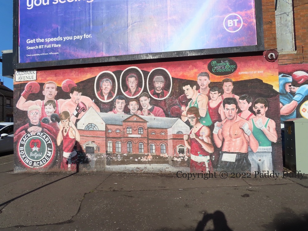
Sacred Heart Boxing Academy was housed in the parochial hall (shown in the middle of the mural) before closing perhaps because of safety concerns and/or debt.
“Ardoyne-Bone boxers have punched well above their weight. As professional we have won … British, Commonwealth, European & W.B.U. titles. As amateurs we have won 3 Olympic bronze, European Gold, Commonwealth Gold, World Junior silver, 17 Irish senior titles & an A.B.A senior title. Nor forgetting all our boxing coaches, who put in their time and effort for all our young boxers. Truly amazing for such a small area.” The wide shot below shows the whole of this new Ardoyne/Ard Eoın mural celebrating local boxers; the boxers named are Darren Corbett (WP), John Kelly (FightsRec), Paddy Barnes (WP), Harry McAuley (BoxRec), Anthony Maguire, Hugh Gilhooley (BoxRec), Eamonn McAuley (BoxRec), Freddie Gilroy (WP), Terry Magee (WP), Sean Brown, Noel Magee (WP), Barney Burns, Pat Kelly, Eamonn Magee (WP).
This image shows the replacement set of painted boards; for the originals see A Small Area.
The board on the left explains the composition of the Union flag as a combination of the saltire of Saint Andrew of Scotland, the cross of Saint George of England, and the saltire of Saint Patrick of Ireland. As the text notes, the saltire is much later than the saint: “The association with Saint Patrick dates from the 1780s, when the Order of Saint Patrick adopted it as an emblem. This was a chivalric order established in 1783 by George III. It is often suggested that it derives from the arms of the powerful FitzGerald dynasty [which dates to the 12th century].”
The text ends oddly: “The saltire has occasionally served unofficially to represent Northern Ireland and [has] been considered less contentious than other flags flown there.” Similar language is used on the symbols.com page for the Saltire.
The central board, shown above, shows a young Patrick (without the clerical garb in which he is often portrayed) against the backdrop of Slemish mountain, where Patrick is thought to have tended sheep as a young slave to a local chieftain, c. 401 AD and developed his Christian faith.
The board on the right shows a ship racing towards shore, superimposed over a 1659 map of Ulster by Blaeu. “The Red Hand Of Ulster: According to legend Ulster had at one time no rightful heir. It was agree that a boat race should take place and that whoever’s hand first touched the shore would become king. One contended, upon seeing that he was losing the race, cut off his hand and threw it ashore to win. O’Neill is said to have been the chieftain who cut his hand off to become the King of Ulster. The Red Hand is a key emblem of Ulster’s identity, an ancient and powerful symbol that is traditionally shown as a blood red hand.”
The colourings of the Saint Patrick profile are by children from the nearby Donegall Road Primary School.
The boards were unveiled on March 10th, 2016 by first minister Arlene Foster who remarked that the saint had become “very Gaelicised” and this — and the presence of Irish tricolours at parades — deterred unionists from celebrating “the patron saint of everybody in Northern Ireland” (Belfast Telegraph; also contains video of the launch). Anglicanism venerates saints but Presbyterianism does not, generally taking the “communion of saints” to refer to all members of the church.
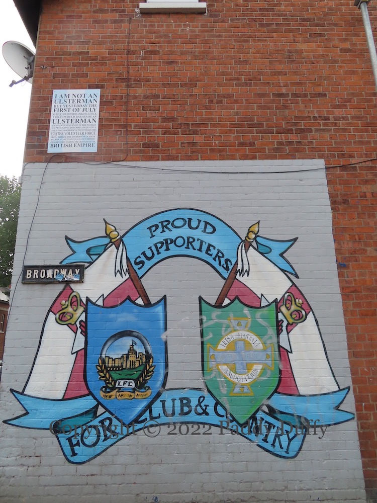
Sport and politics intersect in this mural at the junction of Broadway and Donegall Avenue in south Belfast. Northern Irish flags provide a backdrop for the shields of Linfield football club and the Northern Ireland football association.
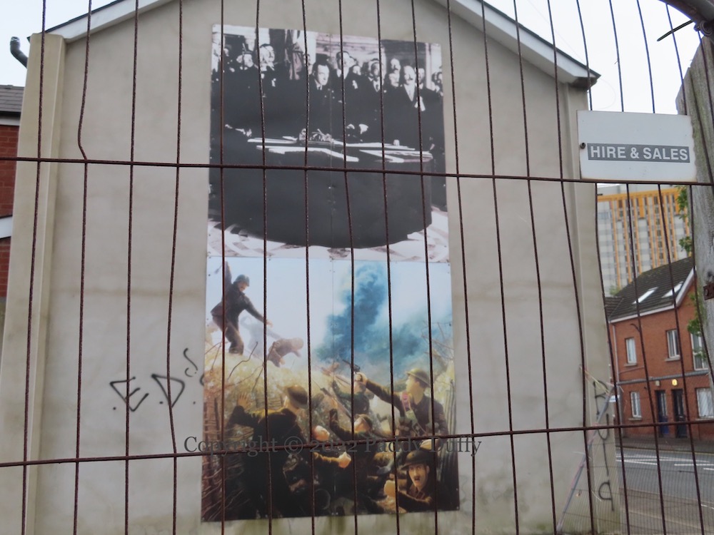
Here are a pair of boards in Barrington Gardens, Belfast: above, the signing of the Ulster Covenant, on September 28th, 1912; below, an attack on British trenches, perhaps intended to represent a scene from the first day of the Battle Of The Somme, July 1st, 1916.
Footballer Billy Simpson moved from Linfield to Rangers in 1950 and over the course of nine years and 239 appearances scored 163 goals. He also scored the winner for Northern Ireland against England in 1957. Simpson died in January of year 2017 and is remembered by this board outside the Supporters’ Club in Barrington Street, south Belfast.
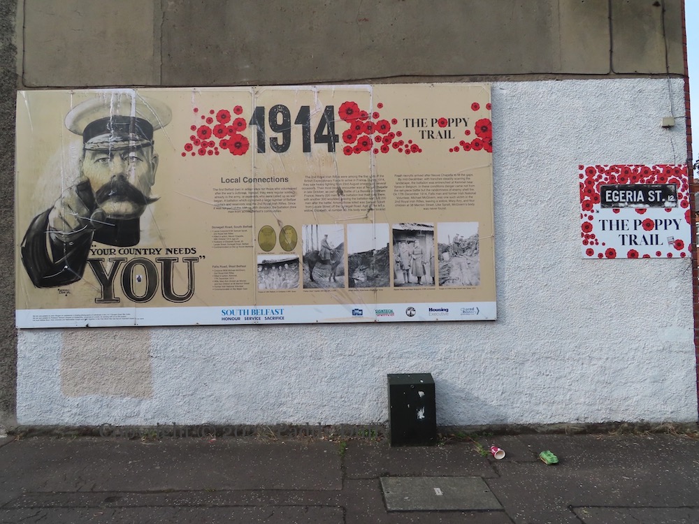
“The first Belfast men in action were not those who volunteered after the war’s outbreak. Instead, they were the regular soldiers already in the army, or reservists who were called up as war began. A battalion which contained a large number of Belfast regulars and reservists was the 2nd Royal Irish Rifles. Since it was not part of the 16th or 36th divisions, the battalion drew men from across Belfast’s communities.”
Thus begins the 1914 board on south Belfast’s “Poppy Trail” launched on February 29th, 2016. The 1914 board features the stories of Lance Corporal Samuel Spratt (from Lecale Street, off the Donegall Road) who died at Neuve Chappelle in August 1914 and Corporal Michael McGivern (from Merrion Street, off the Falls Road) who died at Kemmel in December.
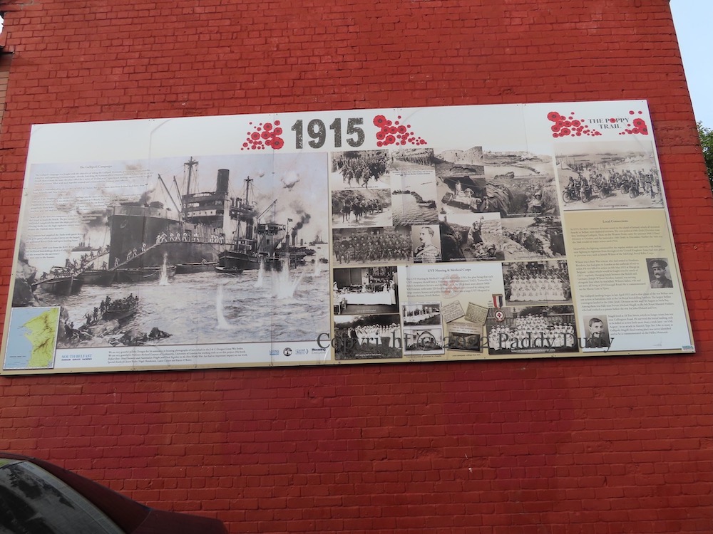
The 1915 board focuses on the Gallipoli campaign, claiming that “more men from Ireland died there than from Australia and New Zealand.” The ship on the left-hand side is the River Clyde, a converted collier, carrying men from the 1st Royal Dublin and 1st Royal Munster Fusiliers, who were decimated as they tried to reach shore — “only 372 of the original 900 1st Royal Munster Fusiliers remained”.
As with the 1914 board, the 1915 board includes the stories of men from both south and west Belfast, in this case, Joseph Wilson, who hailed from Donegall Road and died in Belgium, and Michael Magill, from the Divis area, who died at Gallipoli.
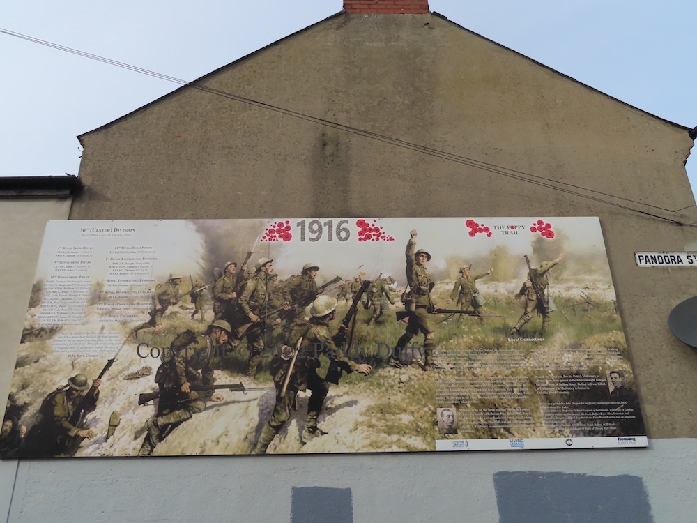
In the 1916 board, JP Beadle’s Battle Of The Somme, Attack Of The Ulster Division is reproduced in the 1916 installment of the Poppy Trail in south Belfast. (For more on the painting, see belfastsomme.com.) In addition to listing local men lost in on July 1st – from places such as Roden, Matilda, Kitchener, Barrington, Blythe, Ebor, Rowland, Abingdon, and Combermere Street – it also features an individual from each community who served and died, in this case, Rifleman Paul Irvine from Lower Rockview Street and Private Patrick McGinney from Balkan Street (in the Divis area).
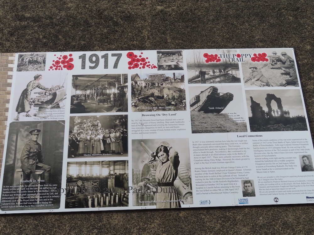
The 1917 board in the Poppy Trail series celebrates female munitions workers as well as making local connections to the battles of 1917: George Cairns of Roden Street and Thomas Fitzpatrick of Cullingtree Road.
Egeria Daphne, Pandora, Euterpe streets, south Belfast. The HMS Hawke board is on the other side of Donegall Road, in Barrington Gardens.
HMS Hawke was a Royal navy WWI cruiser sunk by German U-boat on October 1st, 1914. It was a training ship, which meant that among the 542 sailors who lost their lives on the Hawke, 75 of them were 16 year-old boys. Five of the deceased were from the Donegall Road area.
“This site housed the former Mid Donegall Road Bonfire for over two decades, until the expansion and development of the surrounding area including the City Hospital meant that it was no longer viable for a bonfire to remain on this site. Greater Village Regeneration Trust, through its work with The Health Trust, who own the site, and the local community, including the local bonfire builders wanted to have something on the site that could benefit the whole community and agreement was given for it to be transformed into the garden that is here today. Local Artist Johnny [sic] McKerr worked alongside Greater Village Regeneration Trust and the local community and this artwork was designed to depict and celebrate the heritage, history and culture which the people of this area are extremely proud of.”
The info board includes a photograph of the bonfire spilling out towards the car-park for the City. The other image is a photograph from the Peter Moloney Collection, used without permission, and photoshopped to add “DRL” – Donegall Road Loyalists.
According to Eddie Kelly of the GVRT, Carrickfergus castle is included because “This is where King William landed, and the annual bonfire is a symbol of a beacon lit across the coast to guide him” (Belfast Live).
Painted by JMK/Jonny McKerr (tw) at Coolfin St on Donegall Rd.